

A deficit monsoon that is still drowning people
India's monsoon crisis of 2026 appears contradictory only from a distance.
The country has received below-normal rainfall overall, farmers in several regions are confronting moisture stress, reservoirs remain worryingly depleted, and kharif sowing has fallen behind last year. Yet, at the same time, Assam has suffered one of its most damaging floods in recent years, Arunachal Pradesh has seen nearly its entire district map disrupted at once, Himalayan states are reporting landslides and blocked roads, and intense rainfall episodes are inundating cities and villages from Odisha to Uttarakhand — while Mumbai and Kolkata have each been paralysed by their own floodwaters, and Karnataka has asked farmers to simply stop sowing.
By July 28, the nationwide monsoon rainfall deficit had narrowed to approximately 16 percent, after reaching nearly 40 percent at the end of June. But this apparent recovery has not come through steady, farm-friendly rain. It has largely arrived through violent, concentrated downpours separated by prolonged dry spells.
This is the defining feature of the Indian monsoon of 2026: rain is falling in the wrong places, at the wrong intensity, and increasingly at the wrong time. India is not merely experiencing a weak monsoon. It is experiencing a dangerously disorganised one.
Late arrival, long pause, sudden violence
The southwest monsoon reached Kerala around three days later than usual. It then stalled for nearly two weeks across important agricultural regions of western and central India.
June ended with a severe national rainfall shortage. The monsoon subsequently accelerated, but unevenly. Low-pressure systems and depressions delivered bursts of extreme rainfall, while large areas continued to receive substantially less rain than normal.
Between June 1 and July 22, India had received 19 percent less rainfall than the long-period average. The geographical imbalance was even sharper: East and Northeast India were approximately 32 percent deficient. The southern peninsula was around 26 percent deficient. Northwest India had a deficit of about 13 percent, while central India was approximately 9 percent below normal.
These regional averages conceal extraordinary local variations. A district may receive almost no meaningful rain for two weeks and then receive a month's rainfall in several hours. The monthly total may eventually approach "normal," but the agricultural, hydrological and human consequences are anything but normal. A field needs moderate rain that penetrates the soil. Instead, torrential rain often rushes away as surface runoff, eroding topsoil, flooding settlements and leaving groundwater inadequately replenished.
India's two monsoons are happening together
The 2026 monsoon has effectively divided India into overlapping zones of emergency.
In parts of Bihar, Jharkhand, eastern Uttar Pradesh and the Gangetic agricultural belt, prolonged rainfall deficits created drought-like conditions during crucial sowing weeks. By July 10, rainfall was below normal in 397 of India's 741 districts, while the area under kharif cultivation was approximately 16 percent lower than at the corresponding point in 2025.
Conditions improved later in July, but the sowing deficit did not disappear. By July 24, farmers had planted approximately 78.7 million hectares, against 82.6 million hectares a year earlier. Rice cultivation was slightly behind last year, soybean acreage was down around 3 percent, cotton acreage approximately 4 percent, and maize sowing almost 10 percent lower. Sugarcane was one of the few major crops showing an increase.
Karnataka has offered the sharpest illustration of this stress in the south. The state recorded a rainfall deficit of around 30 percent up to July 11 — having received only 203 mm of rain against a normal of 292 mm — prompting Chief Minister D.K. Shivakumar to write directly to the Prime Minister seeking a central assessment team. June alone was the state's fourth-worst in fifty years, with just 116 mm of rain against a 165–190 mm normal, a 42 percent shortfall. The Malnad region, the principal catchment for the Cauvery, Tunga and Bhadra systems, recorded the state's worst deficit at 34 percent, with the coastal belt close behind at 30 percent. The Tungabhadra reservoir near Hosapete held just 9.47 TMC ft of water against 61.88 TMC ft a year earlier — an 85 percent collapse in storage that has, in comparable past seasons, forced authorities to instruct farmers in the Cauvery basin to halt further sowing altogether.
At the same moment, parts of Assam and Arunachal Pradesh were underwater.
This coexistence is scientifically possible because flood and drought describe different dimensions of water stress. A flood is caused by excessive rainfall or river discharge over a short period and within a particular basin. Drought reflects accumulated rainfall deficiency, reduced soil moisture, poor groundwater recharge, falling reservoir storage and agricultural stress over time. India can therefore be flooded locally while remaining rainfall-deficient nationally.
Assam: an upstream deluge becomes a human disaster
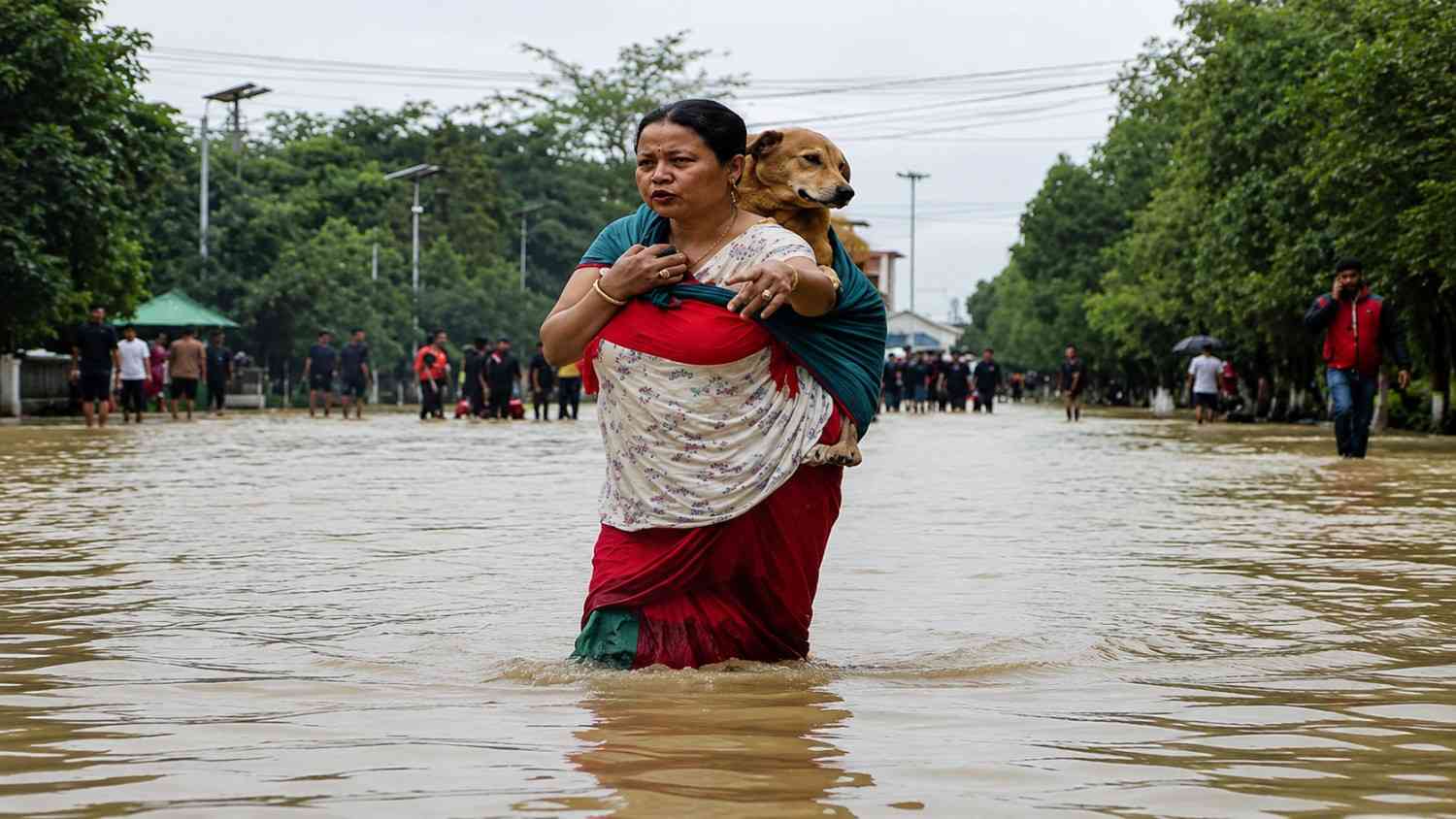
Assam's late-July floods exposed the terrifying speed at which a localised rainfall event can become a regional humanitarian emergency.
Very heavy rainfall over neighbouring Nagaland between July 18 and July 20 generated exceptionally high river flows entering Assam. By July 23, approximately 650,000 people across 11 districts had been affected and at least 36 deaths had been reported during that phase of the disaster.
The crisis subsequently expanded. At its late-July peak, reports indicated that at least 50 people had died, approximately 700,000 had been displaced, nearly 300,000 people were staying in government shelters and around 900 villages were submerged. Helicopters were used for relief drops, while police, disaster-response forces, volunteers and civil administrators conducted rescues.
By July 28, Assam's cumulative flood death toll had reportedly risen to 68, while more than 445,000 people remained affected across districts including Sivasagar, Charaideo, Jorhat, Golaghat, Nagaon and Kamrup Metropolitan. These changing numbers do not represent statistical confusion. They reflect the movement of water: some areas emerge from inundation as others are submerged, displaced residents begin returning, and new deaths or missing persons are recorded.
The state's flood wave first hit Dhemaji, Lakhimpur and Dibrugarh, affecting over 22,000 people and nearly 100 villages, before riverbank erosion partially collapsed a railway bridge over the Simen River at Simen Chapari, cutting off train services and isolating villages overnight. On the ground, response has been substantial: 250 NDRF personnel, 36 NDRF boats, 65 SDRF and Fire Services boats, three Indian Army boats and 82 mobilised country boats have operated around Majuli and the worst-hit districts, alongside 71 relief camps and 202 relief distribution centres. The Chief Minister's Relief Fund has directed distribution of over 4 lakh bottled water units, nearly 2 lakh biscuit packets and roughly 40,000 milk packets for infants, while Cabinet ministers have been stationed in Charaideo and Sivasagar since the floods began. Prime Minister Narendra Modi has personally reviewed relief operations and ordered a full damage assessment, even as opposition leaders have pressed for faster release of PM-CARES funds.
Why does Assam flood again and again?
Extreme rainfall is the immediate trigger. It is not the complete explanation.
The Brahmaputra is a vast, sediment-heavy and highly dynamic river system. It receives water from intense monsoon rain, Himalayan tributaries and numerous upstream catchments. Its channels naturally shift, islands erode and floodplains absorb seasonal excess water. But human interventions have progressively reduced the landscape's capacity to live with the river.
Catchment degradation and deforestation accelerate erosion. Sediment raises riverbeds and reduces channel-carrying capacity. Wetlands and natural water-retention areas are encroached upon. Roads, housing projects and commercial construction block traditional drainage channels. Urban drains are undersized, poorly connected or clogged with waste.
Assam's own urban-flood planning documents acknowledge that rapid development has consumed vacant land and disrupted natural drainage. In Guwahati, the obstruction and encroachment of wetlands and beels have removed natural stormwater reservoirs, allowing even moderate rainfall to produce severe waterlogging.
Embankments provide essential protection, but they can also create a false sense of permanence. When inadequately maintained embankments breach, water enters settlements with extraordinary force. Embankments may also trap rainwater inside protected areas when drainage outlets are insufficient. The result is a cycle of emergency expenditure without corresponding reduction in vulnerability.
Arunachal Pradesh: the upstream disaster nobody watches closely enough
If Assam is the downstream casualty, Arunachal Pradesh is where the water begins its rampage — and the state has been battered on its own terms too. In mid-July, incessant rainfall triggered flash floods in Kurung Kumey district and landslides across Pakke Kessang, West Kameng and Papum Pare districts. The State Emergency Operation Centre reported seven deaths, 29 injuries, and more than 97,000 people affected across 425 villages spanning all 26 districts of the state — nearly the entire state machinery mobilised at once.
The damage inventory reads like an infrastructure ledger wiped out overnight: 150 roads damaged, 19 bridges lost, 21 culverts destroyed, 221 water supply systems disrupted, 58 government buildings hit, 156 power lines and 224 electric poles down, 10 hydel projects damaged, two hospitals and three schools affected, alongside 541.75 hectares of crop area and nearly 1,010 hectares of forest land impacted. In Kurung Kumey, flash floods from the overflowing Kumey River washed away bridges connecting the villages of Huri, Damin and Pagam; a church, an inspection bungalow, and St Thomas School in Parsi-Parlo were all damaged, halting classes. A massive landslide buried a stretch of National Highway-13 near Pakro village, and a section of the road leading to the strategically vital Sela Tunnel in West Kameng — a key route toward the China border — was washed away entirely.
Downstream and around, the same monsoon has scattered damage widely: a Bailey bridge over the Phee Khola at Phidang in North Sikkim's Dzongu region was simply washed away, cutting off road connectivity, while Meghalaya's hill roads suffered fresh landslide disruptions of their own. Arunachal Pradesh illustrates, in miniature, the whole country's 2026 paradox: a state that can log both flood emergencies in its river valleys and rainfall deficits in its interior districts within the same season — sometimes the same week.
The drought is hiding inside the reservoirs
Flood images dominate television screens because they are immediate and dramatic. Reservoir depletion receives far less attention, although it can affect drinking water, irrigation, electricity generation and food prices for months.
On July 23, the country's 166 monitored major reservoirs held approximately 70.4 billion cubic metres of water, equivalent to only about 38 percent of their combined capacity. Storage was around 36 percent lower than at the same time in 2025. More than 50 reservoirs were holding water at or below 80 percent of their normal level, while 22 were at half their normal storage or lower. Conditions were especially concerning in parts of southern India — a picture Karnataka's near-empty Tungabhadra reservoir makes vivid.
This is hydrological stress, even when isolated districts are reporting floods. Much of the rain produced by cloudbursts and extreme spells runs rapidly into rivers and drains. It may cause destruction without adequately restoring groundwater or maintaining reservoir inflows. The nation receives water, but cannot retain it where and when it is needed.
El Niño has disturbed the monsoon's rhythm
The most prominent large-scale climate influence in 2026 is El Niño — the abnormal warming of the central and eastern equatorial Pacific Ocean. The World Meteorological Organization had assessed an approximately 80 percent probability of El Niño conditions during June–August 2026, with a very high probability that the event would continue into late autumn. By July, the India Meteorological Department reported that El Niño conditions were prevailing and strengthening, while the Indian Ocean Dipole remained neutral.
El Niño often weakens India's seasonal monsoon circulation. But it does not simply switch off rainfall. It can weaken the broad flow of moisture while atmospheric disturbances, Bay of Bengal depressions, western disturbances, the movement of the monsoon trough and the Madden–Julian Oscillation still generate intense local rainfall. This year, western disturbances — normally quiet during the monsoon — have remained active and interacted directly with the monsoon current over Jammu & Kashmir and the western Himalaya, intensifying rainfall precisely where slopes are least equipped to absorb it.
Research examining more than a century of observations indicates that some El Niño years can simultaneously increase the probability of seasonal rainfall deficiency and short-duration extreme rainfall over particular regions. Thus, fewer rainy days do not necessarily mean fewer disasters. They may mean that a larger proportion of the season's rain falls during a smaller number of violent events.
Climate warming is loading the dice
El Niño is a natural climate cycle. The background against which it now operates is no longer natural.
India's average temperature increased by approximately 0.7°C between 1901 and 2018. A warmer atmosphere can hold more moisture, while rising sea-surface temperatures increase the potential supply of water vapour to monsoon systems. This produces an apparent paradox: warming can intensify both drought and flooding. Higher temperatures increase evaporation from soil, plants and reservoirs during rainless periods. But when atmospheric conditions finally trigger rain, the additional moisture can produce much heavier precipitation.
The Intergovernmental Panel on Climate Change has projected increasing heavy precipitation over parts of Asia and the Himalayan region, alongside declining snow and glacier volumes. Climate change does not cause every individual flood or landslide. It multiplies the probability, intensity and consequences of extreme events occurring within already vulnerable landscapes.
The Himalaya: a natural hazard turned into a construction zone
The Himalaya are geologically young, steep and unstable. Their rocks are fractured, their slopes are vulnerable to erosion, and intense rain can rapidly saturate thin mountain soils. Yet natural fragility is only half the story.
Road widening, uncontrolled hill cutting, blasting, hotel construction, hydropower infrastructure, poorly designed retaining walls and the dumping of excavated debris have transformed many mountain slopes. Drainage channels are frequently blocked or redirected. Buildings have expanded onto unstable slopes and river terraces without adequate geological assessment. India's Supreme Court, reviewing disaster patterns in Himachal Pradesh, has explicitly named hydroelectric power projects, four-lane road expansion, deforestation and unchecked multi-storey construction as drivers of "ecological destruction," warning that revenue "cannot be earned at the cost of the environment and ecology."
India's national landslide atlas has mapped around 80,000 landslides recorded between 1998 and 2022 across 17 states and two Union Territories, and ranked 147 districts by landslide exposure. Many vulnerable corridors include major pilgrimage routes, highways and densely visited tourist centres. By July 28, rain and landslides had reportedly blocked as many as 179 roads in Himachal Pradesh, while at least 15 monsoon-related deaths had been recorded in the state.
Glacial retreat compounds the risk. The Hindu Kush Himalaya region has seen glacial cover shrink 12 percent between 1990 and 2020, with a 21 percent decline in the Ganga basin alone. ISRO's Glacial Lakes Atlas has identified roughly 2,400 glacial lakes, of which 601 have doubled in size and are considered at risk of catastrophic breach. The 2023 Sikkim GLOF remains the starkest warning of what this looks like in practice: permafrost erosion triggered a landslide into South Lhonak Lake, producing a 20-metre flood surge that destroyed the Teesta-III dam, killed at least 90 people, and inundated 276 square kilometres of farmland. The 2023 Joshimath subsidence crisis and the 2025 Dharali flash flood — which buried a Himalayan village under 12–18 metres of sediment — are cut from the same cloth: tectonic stress compounded by construction, tunnelling and drainage failures that turned a natural hazard into a man-made catastrophe.
The Northeast faces similar risks. Recent modelling of rain-triggered landslides in Mizoram suggests that simultaneous slope failures with little or no warning could become substantially more frequent under high-emissions warming scenarios. The study remains a modelling assessment rather than a precise forecast, but its warning is unmistakable: yesterday's engineering standards cannot be assumed to protect tomorrow's mountains.
Metros drowning by design: Mumbai and Kolkata
While hill states battle landslides and the Northeast battles rivers, India's two biggest western and eastern metros have spent the season proving that flooding isn't only a mountain or a river problem — it is also, unmistakably, an urban planning failure.
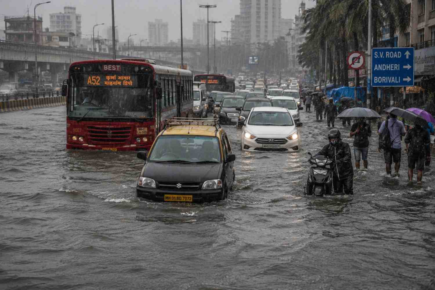
Mumbai's stormwater drainage network was designed in the early twentieth century to handle roughly 25 mm of rainfall per hour — a fraction of what the city's monsoons now regularly deliver. The 2005 catastrophe, when the city recorded 944 mm of rain in 24 hours, was supposed to be the wake-up call; the Chitale Committee that followed recommended sweeping drainage reforms and a dedicated authority for the Mithi River. Two decades on, areas like Bandra Kurla Complex and Hindmata still flood on cue every season — 2017, 2019, 2021, 2023, 2025, and again in 2026. The city's exposure is structural and largely self-inflicted: Mumbai was built by reclaiming seven islands, leaving large portions of the metropolis below high-tide level to begin with. Its drainage outfalls discharge directly into the sea, which works fine at low tide — but when heavy rain coincides with high tide, sluice gates must be shut to stop seawater backflow, trapping rainwater inside the city with nowhere to go. Layer on decades of destroyed mangroves, blocked natural nullahs, and — as the Bombay High Court itself observed this July — citizen and civic complicity in encroaching on drains, blocking gutters, and converting footpaths and open channels into shops and parking, and you get a city whose flooding the court bluntly called "our own creation." Mumbai's open-space ratio has been measured at roughly 0.012 hectares per 1,000 people, against a desired standard of 1.67 hectares — a 140-fold shortfall that leaves almost nowhere for excess water to go except the streets.
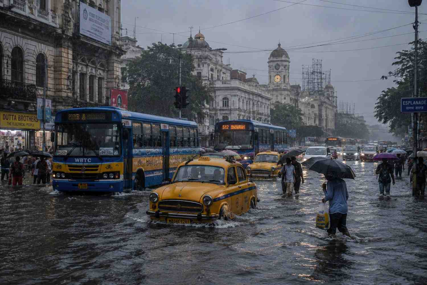
Kolkata's flooding operates on an almost identical playbook. In one recent extreme event, the city logged 252 mm of rain in seven hours — arriving at the same moment as high tide on the Hooghly, forcing the Kolkata Municipal Corporation's drainage department to shut sluice gates and trap the deluge inside the city. As Mayor Firhad Hakim put it, describing the scale of the downpour: the canals and rivers were already full, so every attempt to drain the city simply invited more water back in. The deeper story is ecological. Kolkata's eastern wetlands once functioned as the city's natural stormwater sponge — but decades of illegal landfilling along the Eastern Metropolitan Bypass have destroyed much of that buffer for construction. Combined with a colonial-era sewerage network never rebuilt for today's population density, the result is a city where a few hours of intense rain can paralyse roads, rails, the Metro, hospitals, and festival infrastructure alike. The KMC's own diagnosis has been candid: erratic weather patterns are now delivering brief, torrential downpours that simply exceed what the ageing drainage network can pump into the canals in time. In response, the corporation has begun constructing rainwater-collection reservoirs at more than 50 identified "water pocket" locations, aiming to both cut waterlogging and recharge depleting groundwater — an admission, in itself, that pumping alone can no longer keep pace with the rain.
Relief is necessary. Rehabilitation must not recreate risk
Governments have mobilised rescue teams, opened relief camps, distributed food and drinking water, restored communications and used helicopters in inaccessible areas. The Prime Minister and Assam's Chief Minister have reviewed the flood situation, while central assessment teams and state agencies have begun examining losses and rehabilitation needs. In Himalayan states, highway authorities have identified vulnerable locations, positioned machinery and emergency teams, and undertaken slope stabilisation, retaining-wall, drainage and erosion-control work. In Arunachal Pradesh, the State Emergency Operation Centre has coordinated restoration of roads, bridges and water systems even as damage assessments continue across all 26 districts. In Mumbai and Kolkata, municipal corporations have leaned on additional pumps, desilting drives, and new underground rainwater-storage reservoirs — tactical measures that civic officials themselves concede are stopgaps against a structurally undersized system.
But relief measured only by food packets, rescue boats and compensation cheques is incomplete. Relief camps need safe water, sanitation, health surveillance, menstrual hygiene facilities, child protection, disability access and arrangements for livestock. Families losing crops, shops, fishing equipment or daily-wage employment need immediate livelihood assistance, not merely compensation for damaged houses. Rehabilitation must rebuild schools, clinics, transport links and local markets — not only physical dwellings. Most importantly, homes repeatedly destroyed by erosion or landslides should not simply be reconstructed at the same location.
Stop repairing disasters. Start redesigning risk
Assam already has major flood-management initiatives supported by the World Bank and the Asian Development Bank. These include institutional strengthening, better flood forecasting, embankment and river-management measures, erosion control and climate-resilient infrastructure. Their success must be judged not by money spent or embankment kilometres completed, but by lives protected, warnings delivered, evacuation time gained and repeated displacement prevented.
Every major flood and landslide should trigger an independent, publicly available review examining land-use violations, wetland destruction, drainage failures, embankment maintenance, road design, debris disposal, reservoir operations and administrative response. India needs legally enforceable floodplain zoning. Urban wetlands must be mapped, protected and restored — in Guwahati's beels, Kolkata's eastern marshes and Mumbai's mangroves alike. Encroachments blocking natural watercourses cannot be regularised indefinitely and then blamed on "unprecedented rain." Each embankment should have a public asset register, pre-monsoon safety certification and clearly identified maintenance responsibility. River management must incorporate sediment and erosion control, not merely build higher walls against water.
The Himalaya needs a carrying-capacity test
Every road, tunnel, hydropower project, hotel cluster and township in vulnerable mountain districts should be evaluated cumulatively. A project may appear manageable in isolation. Ten projects on the same unstable slope or river valley may create an entirely different hazard. High-susceptibility zones need strict no-construction rules. Road engineering must give priority to drainage, controlled excavation, slope reinforcement and scientific disposal of debris. Pilgrimage and tourism numbers should be aligned with local carrying capacity, evacuation routes and waste-management infrastructure. Development cannot be called development when each monsoon washes it away and leaves local residents to carry the debt, debris and deaths.
Forecasts must reach the last household
The IMD is increasingly issuing impact-based rainfall warnings, including alerts for flash flooding, landslides, crop damage and urban inundation. During the final week of July, it warned of extremely heavy rainfall across parts of Odisha, Chhattisgarh, Madhya Pradesh and Gujarat, along with very heavy rainfall over Himalayan states. But a forecast is only as useful as the action it triggers. Warnings must be converted into local languages, cell-broadcast alerts, sirens, community announcements and pre-agreed evacuation orders. Village volunteers, schools, local health workers and elected representatives must know exactly what a red or orange warning requires them to do. Forecast accuracy cannot compensate for administrative hesitation.
2026 is not an abnormal year to be forgotten
The Indian monsoon of 2026 is a warning about the future of adaptation. It demonstrates that national rainfall averages are no longer enough. Policymakers must examine rainfall intensity, dry-spell duration, soil moisture, reservoir storage, district-level crop conditions and the exposure of people living along rivers, hills and urban drains.
India requires an adaptation architecture capable of responding to simultaneous scarcity and excess. Farmers need drought-resistant seeds, crop insurance that pays quickly, local water harvesting and advisories based on actual soil conditions. Cities need permeable surfaces, functioning drains and restored wetlands. Floodplains need space for rivers. Himalayan districts need enforceable geological limits. Erosion-displaced families need legal recognition, secure relocation and livelihood support.
The choice is no longer between development and environmental protection. The real choice is between development that survives the monsoon and development that becomes its next casualty.
India is receiving less rain than normal nationally while people are dying from too much water locally. That is not a contradiction to be explained away. It is the clearest possible signal that the climate has changed faster than the country's systems of planning, construction, agriculture and disaster governance.
The rain is no longer waiting for India to adapt.
Sources referred to
- India Meteorological Department (IMD) — seasonal and district-wise rainfall bulletins, 2026
- World Meteorological Organization (WMO) — El Niño probability assessments, 2026
- Intergovernmental Panel on Climate Change (IPCC) — regional precipitation and glacier projections
- Assam State Disaster Management Authority / Chief Secretary review bulletins, July 2026
- Assam Chief Minister's Office / DRIMS (Disaster Reporting and Information Management System) bulletins
- ANI — "NDRF, SDRF providing special support in Assam": Union Minister Sarbananda Sonowal (July 24, 2026); "Assam flood death toll rises to 68, CM Himanta Biswa Sarma directs coordinated relief operations"
- Assam Tribune — "Assam plans minister-led rehabilitation in flood-hit districts after Assembly"
- Sentinel Assam — "Assam Chief Secretary Reviews Flood Situation, Directs Faster Relief and Restoration in Worst-Hit Districts"
- Asian Mirror — "Assam Floods Turn Deadly: Death Toll Reaches 62, Over 7 Lakh People Affected"
- The Tribune — "Kharge targets BJP over Assam floods, demands immediate PM-CARES relief"
- State Emergency Operation Centre (SEOC), Government of Arunachal Pradesh — disaster bulletins, July 2026
- India TV News — "7 killed, over 97,000 affected as heavy rains trigger landslides, flash floods in Arunachal" (July 2026)
- Daily Pioneer — "Fresh Floods and Landslides Hit Arunachal Pradesh, Over 97,000 Affected" (2026); "Himalayan Climate Crisis: Why India Must Rethink Mountain Development Before It's Too Late"
- The News Minute — "Floods and landslides batter northeast India"
- Union Ministry of Agriculture and Farmers Welfare — kharif sowing progress data, 2026
- Central Water Commission — national reservoir storage bulletins, 2026
- News9live — "Karnataka CM writes to PM over worsening drought after 30% rainfall deficit"; "Karnataka sees 42% June rain deficit, Tungabhadra storage drops sharply"
- Deccan Chronicle — "Karnataka: 'Send A Central Team...' CM Tells PM"
- The Hans India — "Wide deficit in southwest monsoon rainfall sparks drought concerns"
- Tractor For Everyone — "IMD Monsoon 2026 Forecast: Below-Normal Rains & Kharif Sowing Impact"
- Sunday Guardian Live — "Mumbai Monsoon Arrival 2026: Is the City Ready to Tackle Waterlogging?"
- Free Press Journal — "Mumbai's Flooding, 'Our Own Creation,' But Not Ours Alone" (Bombay High Court observation, July 2026)
- Mumbai TV — "Mumbai Monsoon 2026: Heavy Rain Floods Roads, Disrupts Traffic and Tests City's Infrastructure"
- India.com — "Why does Mumbai continue to face severe flooding during the monsoon despite years of infrastructure upgrades?"
- ETV Bharat — "KMC Will Collect Excess Rainwater To Address Inundation, Replenish Depleting Groundwater"
- The Federal — "What caused Kolkata floods? A near-cloudburst, outdated drainage, ecological apathy"; "Flood here, drought there: A tale of two Indias in monsoon"
- Millennium Post — "KMC gears up for borough-level monsoon review" (2026)
- Down To Earth — "India's Erratic Monsoon: Floods, Dry Spells and a 16% Rain Deficit Driven by El Niño and Global Warming"
- Geological Survey of India — National Landslide Susceptibility Atlas
- Insights on India / Drishti IAS — "Himalayan Fragility: Causes, Consequences, and the Way Ahead for Sustainable Development"; "Strengthening Himalayan Disaster Preparedness"; "Building Resilience Against Landslides"
- Observer Research Foundation (ORF) — "Climate Extremes and the Development Dilemma in the Himalayas"
- ISRO Glacial Lakes Atlas; ICIMOD Hindu Kush Himalaya assessment, 2026
- World Bank / Asian Development Bank — Assam flood and river-management project documentation




Add a Comment